St. Louis MetroLink Green Line
What is the MetroLink Green Line?
The MetroLink Green Line is the proposed light rail expansion project in the Northside- Southside corridor in the City of St. Louis. The project includes 10 stations and 5.6 miles of in-street light rail running from Jefferson Avenue at Chippewa Street north to Natural Bridge Avenue in the City of St. Louis, while connecting with the current MetroLink system via a transfer station.
The City of St. Louis proposed Green Line project will be designed to preserve and enhance existing neighborhoods, promote unity, achieve regional objectives, reinforce existing public and private investments, and provide improved transportation for a substantiated number of people. The project will also provide equitable access to jobs, help revitalize neighborhoods and support Justice40 Initiative principles.
The purpose of the MetroLink Green Line is to provide new access to growing and established job centers for residents with limited transportation options and to invest in historically underserved neighborhoods. In February, the project passed a major milestone when East-West Gateway Council of Governments, the St. Louis region’s metropolitan planning organization, approved the revised light rail line as the locally preferred alternative (LPA).
The revised alignment from the 2018 study includes ten stations and three possible additional design options/stations under consideration. Although Palm St./Salisbury St. Station, Russell Blvd. Station, and Arsenal St. Station from the 2018 study were removed and are now design options, stations continue to be located every 0.6 miles with narrower platforms, sidewalks and buffer allowances and decreased lane capacity. Approval of the LPA paved the way for the project to advance to the current environmental analysis and 30% design as well as seek entry into the Federal Transit Administration’s Capital Investment Grants pipeline, a multi-year process.
The Green Line will utilize low-floor MetroLink vehicles in the street operating within a dedicated right-of-way area (no cars allowed) separated from traffic by a curb. This will enhance safety and improve train travel times.
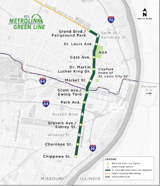 Proposed Station Sites include the following from the South terminus to the north:
- Chippewa St. Station
- Southern most stop
- Provides transit hub to dense residential neighborhoods
- Cherokee St. Station
- Provides light rail connection to the Cherokee Street business district
- Service to dense residential neighborhoods
- Gravois Ave./Sidney St. Station
- Creates transportation hub along Gravois Ave.
- Park Ave. Station
- Provides direct connection to Lafayette Park Business District
- Access to dense residential neighborhoods
- Scott Ave./Ewing Yard Station
- Station connection to Red and Blue Lines
- Access to enlarged Vehicle Maintenance Facility
- Market St. Station
- Serves extensive development area in downtown St. Louis
- Access to office and commercial within walking distance
- Link to Brickline Greenway
- MLK Drive Station
- Offers Access to Schools, Neighborhoods, Social Service Agencies and businesses within half mile of this area
- Cass Ave. Station
- Connection to Next NGA West Campus
- Significant amounts of developable acreage directly adjacent to Cass Ave. Station
- St. Louis Ave. Station
- Creation of transportation node at northern end of the Next NGA West Campus
- Direct connection to the Brickline Greenway
- Grand Blvd./ Fairground Park Station
- Direct access to Fairground Park
- Northern most stop on Green Line
- Direct Link to Brickline Greenway
- 5 miles from St. Louis County for potential future transit access/development
Take a tour of the proposed alignment here:
Where is the project now?
The project is currently in the environmental analysis and 30% design phase. The environmental analysis is a requirement of the National Environmental Policy Act (NEPA) when seeking federal funding. During NEPA, the Green Line project team will assess potential project impacts on the human and natural environment then examine ways to avoid, minimize or mitigate adverse effects where feasible. This process ensures that the project will not significantly impact key environmental resources, such as air and water quality, or adversely impact low-income individuals or communities of color. During 30% design, major design elements, the project timeline and project costs will be fine-tuned.
Northside-Southside Corridor Profile:
- 25% of households within walking distance of the alignment do not own a vehicle
- 10% of workers near the alignment rely on public transit to get to work
- 17% of all current affordable housing units (city-wide) are within walking distance of these new stations.
- Several parts of the alignment have the highest rates of transit use in the region.
Find out more here: www.metrolinkgreenline.com
Additional Resources:
CMT “Talking Transit” Presents:
- Intersection of Transit Access & Public Health
- State of Transit in the Region in 2024
- Where do you see your MetroLink stop in the future?
Transit-Oriented Development: