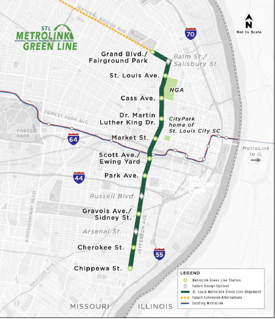
The City of St. Louis and Bi-State Development are working to build a new Green Line that extends light rail service north and south of the existing MetroLink system within the City of St. Louis. As a part of that work, the City of St. Louis Planning & Urban Design Agency (Agency) proposed modest changes to the Zoning Code for parcels near the proposed stations to realize the full benefits of Transit-Oriented Developments. Today, Mayor Tishaura O. Jones has signed Board Bill 13, reducing minimum lot sizes by 40%, adjusting height maximums from three to four floors, and decreasing parking minimums by 25%, for parcels in certain zoning districts within half a mile of the 10 proposed stations.
“The expansion of MetroLink with the new Green Line, along with this important bill, will enhance walkability and support residents along this corridor, improving their quality of life and ability to get around our City,” said Mayor Tishaura O. Jones. “By responsibly loosening restrictions on parking, the maximum number of floors, and the minimum size of lots, we’re making it easier for those alongside the Green Line to invest in St. Louis and help neighborhoods to grow and be full of life and opportunity.”
Transit-Oriented Developments (TODs) are developments that utilize the benefits of transit access to create compact, mixed-use communities where residents/riders enjoy easy access to jobs and services throughout the community. According to the Agency, the goal of these policy changes in the City would include:
- Help preserve and revitalize economically underinvested neighborhoods.
- Add diversity to the existing housing stock and increase the supply of affordable housing.
- Increase ridership of transit systems and reduce traffic congestion.
- Improve pedestrian opportunities and walkability.
- Improve air quality and reduce climate change-inducing greenhouse gasses; and
- Encourage public and private developments and public investment.
The proposed 5.6-mile Green Line extension could provide a new, high-quality transportation option for residents of St. Louis, catalyze investment in historically underserved neighborhoods, and help the region compete for new jobs and residents. The planned project travels along Natural Bridge Avenue, Parnell Street, and Jefferson Avenue from Fairground Park/Grand Ave. on the north to Chippewa Street on the south. The project’s route including 10 proposed stations was officially adopted by the East-West Gateway Council of Governments Board of Directors in February of 2024 as the “Locally Preferred Alternative.”
There are more than 400 acres of vacant property (both land and buildings) within a half-mile radius around the proposed 10 Green Line stations; over 70 acres are owned by the City’s Land Reutilization Authority (LRA). These vacant parcels are opportunities for housing, retail, office, services, and other transit-supportive uses. Small changes to the zoning code could reduce barriers to reusing vacant properties for transit-oriented development—housing, mixed-use, office, retail, grocery, and more. The proposed changes include a context-appropriate increase in density, and requiring slightly less parking, which will make it easier to provide a range of housing options, and build up the neighborhood density in a way that supports future transit access and ridership.
“We applaud the City of St. Louis for proactively looking at ways to maximize the benefits of any transit expansion project within the City of St. Louis, but especially in light of this large-scale transit infrastructure project. The benefits of transit go far beyond the ride from point A to Point B, and laying the groundwork through policy changes to see increases in the development and economic impact benefits of transit definitely ensures this project is on track for success,” said Kimberly Cella, executive director of CMT.
